Chapter 1: Introduction to Satellite Technology
“The sky is no longer the limit—it is the beginning.”
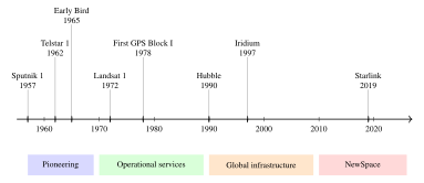
The advent of the Space Age in 1957 marked one of the most consequential technological transitions in human history. Within a single generation, humanity moved from the first tentative orbital insertion of an artificial satellite to the deployment of mega-constellations comprising thousands of spacecraft providing global broadband internet. Today, satellites underpin nearly every facet of modern civilization: global communications, precise navigation, weather forecasting, Earth observation, scientific discovery, and national security. This chapter introduces the foundational concepts of satellite technology, traces the historical arc from Sputnik to Starlink, situates the discipline within the broader context of the commercial space economy, and provides a roadmap for the remainder of this book (Wertz et al. 2011).
1.1 A Brief History of the Space Age
1.1.1 Prelude: Theoretical Foundations
The intellectual heritage of satellite technology stretches back several centuries. In 1687, Sir Isaac Newton published his Philosophiae Naturalis Principia Mathematica, in which he described the concept of a cannonball fired from a mountaintop with sufficient velocity to fall around the Earth indefinitely—the conceptual birth of orbital mechanics. Konstantin Tsiolkovsky, a Russian schoolteacher, published his seminal 1903 paper “The Exploration of Cosmic Space by Means of Reaction Devices,” deriving the rocket equation that still bears his name and postulating the use of liquid propellants for space travel. Hermann Oberth in Germany and Robert Goddard in the United States independently advanced the theoretical and experimental basis for liquid-fueled rocketry throughout the 1920s and 1930s.
Arthur C. Clarke’s 1945 paper “Extra-Terrestrial Relays: Can Rocket Stations Give World-Wide Radio Coverage?” published in Wireless World first proposed the use of satellites in geostationary orbit (approximately 35,786 km altitude) for global telecommunications relay—a vision realized within two decades. The altitude of geostationary orbit is now often called the “Clarke orbit” in his honor.
1.1.2 The Sputnik Era (1957–1961)
The Space Age began on 4 October 1957, when the Soviet Union successfully launched Sputnik 1 (Russian: Sputnik, meaning “fellow traveller”), the world’s first artificial Earth satellite. Sputnik 1 was a polished aluminum sphere 58 cm in diameter, with a mass of 83.6 kg and four whip antennas broadcasting at 20.005 MHz and 40.002 MHz. Its elliptical orbit had a perigee of 215 km, an apogee of 939 km, and an inclination of 65.1\(^\circ\); the satellite completed one orbit every 96.2 minutes. Though technologically simple, Sputnik 1’s political impact was seismic: it demonstrated Soviet capability to place objects in orbit—and by extension, to deliver nuclear warheads anywhere on Earth.
The United States responded with Explorer 1, launched on 31 January 1958 atop a Jupiter-C rocket. Explorer 1 carried a scientific payload designed by James Van Allen of the University of Iowa: a Geiger–Müller counter to measure cosmic radiation. The unexpected data returned by Explorer 1 led to the discovery of the radiation belts encircling Earth, later named the Van Allen radiation belts—one of the first major scientific discoveries of the Space Age.
The National Aeronautics and Space Administration (NASA) was established on 1 October 1958, consolidating U.S. civilian space activities. Concurrently, the Advanced Research Projects Agency (ARPA, later DARPA) was created to prevent future technological surprises.
The term “satellite” derives from the Latin satelles, meaning an attendant or guard. In astronomy, it originally referred to natural moons orbiting planets. The prefix “artificial” was initially used to distinguish human-made orbital objects but has since been dropped in common usage; “satellite” today typically implies an artificial construct unless otherwise specified.
1.1.3 The Communications Satellite Revolution (1960–1970)
The first experiments with satellite communications used passive reflectors. Echo 1, launched in August 1960, was a 30-meter aluminized balloon that served as a passive microwave reflector; it demonstrated the feasibility of satellite communications but required extremely high transmitter power due to the geometric spreading of reflected signals.
Active communications satellites—those with onboard receivers and transmitters—quickly superseded passive designs. Telstar 1, launched on 10 July 1962 by AT&T Bell Laboratories aboard a Thor-Delta rocket, was the first active communications satellite. Operating in an elliptical orbit (perigee 952 km, apogee 5632 km), Telstar 1 successfully relayed the first live transatlantic television pictures and telephone calls. However, its non-geostationary orbit limited contact windows to approximately 20 minutes per pass, demonstrating the appeal of GEO for continuous communications coverage.
The true commercial communications satellite era began with Early Bird (later renamed Intelsat I), launched on 6 April 1965 into geostationary orbit. Built by Hughes Aircraft Company, Early Bird had a capacity of 240 voice circuits or one two-way television channel—modest by today’s standards but transformative for transatlantic communications of the era. Early Bird validated Clarke’s 1945 vision and established the geostationary arc as the preferred venue for telecommunications satellites for the next half-century.
1.1.4 Navigation and Earth Observation (1960–1980)
The Transit navigation satellite system, developed by the Applied Physics Laboratory of Johns Hopkins University for the U.S. Navy, became operational in 1964. Transit satellites in polar LEO (approximately 1000 km altitude) transmitted Doppler-shifted signals; receivers on ships could determine their position with an accuracy of approximately 200 m by measuring Doppler shift over a pass. Transit demonstrated the principle of satellite navigation that would underlie GPS.
The Global Positioning System (GPS), formally known as NAVSTAR GPS, was authorized by the U.S. Department of Defense in 1973 and reached initial operational capability (IOC) in 1993, with full operational capability (FOC) declared on 27 April 1995. The first Block I GPS satellite (Navstar-1) was launched on 22 February 1978. The GPS system represented a qualitative leap: it provided three-dimensional positioning, velocity, and time to any user on or near Earth’s surface with a precision unattainable by previous systems.
Earth observation satellites began with TIROS-1 (Television and Infrared Observation Satellite) in April 1960, which returned the first weather satellite imagery. The Landsat program, initiated with Landsat 1 (originally ERTS-1) in July 1972, established continuous multispectral imaging of Earth’s land surface. Landsat data has provided an uninterrupted, 50-year record of land-cover change, deforestation, glacial retreat, and urban expansion—an irreplaceable scientific archive.
1.1.5 The Hubble Space Telescope and Beyond (1990–Present)
The Hubble Space Telescope (HST), launched on 24 April 1990 aboard Space Shuttle Discovery, exemplifies the scientific capability of large, serviceable space observatories. Despite the initial embarrassment of a spherical aberration in the primary mirror, corrective optics installed during a 1993 servicing mission transformed HST into the most productive scientific instrument in history by many metrics, yielding over 18,000 peer-reviewed publications.
The International Space Station (ISS), the largest human-made structure in space, has been continuously inhabited since November 2000. With a mass exceeding 420,000 kg and pressurized volume of approximately 916 m\(^3\), the ISS represents the collaborative effort of fifteen nations and has hosted over 3,000 scientific investigations.
The modern era is defined by the NewSpace revolution: the entry of commercial enterprises into domains previously reserved for government space agencies. SpaceX’s Starlink constellation, with over 5,000 satellites in LEO as of early 2024, provides broadband internet services globally and represents the largest constellation ever deployed. OneWeb, Amazon Kuiper, and Telesat Lightspeed are developing competing broadband LEO constellations. Small satellite manufacturers such as Planet Labs, Spire Global, and Satellogic have democratized Earth observation with hundreds of small spacecraft providing daily global coverage.
1.2 Table of Major Satellite Firsts
Table 1.1 summarizes the landmark satellites that defined the evolution of space technology. Each entry represents a qualitative advance in capability or a new application domain.
| Satellite | Country | Launch Date | Orbit | Significance |
|---|---|---|---|---|
| Sputnik 1 | USSR | 4 Oct 1957 | LEO (215\(\times\)939 km) | First artificial Earth satellite |
| Vanguard 1 | USA | 17 Mar 1958 | LEO (654\(\times\)3969 km) | Oldest satellite still in orbit; confirmed Earth’s oblate shape |
| Explorer 1 | USA | 31 Jan 1958 | LEO (357\(\times\)2546 km) | First US satellite; discovered Van Allen belts |
| Echo 1 | USA | 12 Aug 1960 | LEO (1519\(\times\)1687 km) | First passive communications satellite |
| Telstar 1 | USA | 10 Jul 1962 | MEO (952\(\times\)5632 km) | First active comms sat; first transatlantic TV |
| Syncom 3 | USA | 19 Aug 1964 | GEO | First true geostationary satellite |
| Early Bird (Intelsat I) | USA/Intl | 6 Apr 1965 | GEO | First commercial GEO communications satellite |
| Landsat 1 (ERTS-1) | USA | 23 Jul 1972 | LEO (900 km SSO) | First Earth resources satellite |
| NAVSTAR GPS Block I | USA | 22 Feb 1978 | MEO (20,200 km) | First GPS satellite |
| Hubble Space Telescope | USA/ESA | 24 Apr 1990 | LEO (547 km) | Premier space observatory; 15,000+ publications |
| Iridium (constellation) | USA | 1997–1998 | LEO (780 km) | First global mobile satellite phone system |
| ISS (first module: Zarya) | Russia/USA | 20 Nov 1998 | LEO (408 km) | Largest cooperative human spaceflight structure |
| Starlink Gen1 | USA | 24 May 2019 | LEO (550 km) | Began largest-ever LEO broadband constellation |
1.3 Why Satellites? The Unique Value Proposition
The sustained, multi-decade investment in satellite technology across scores of nations and now hundreds of commercial enterprises reflects a genuine and durable set of advantages that satellites offer over terrestrial alternatives (Elbert, B.R. 2008).
1.3.1 Global Coverage and Persistence
A single geostationary satellite, positioned at 35,786 km altitude over the equator, has a theoretical line-of-sight coverage of approximately 42% of Earth’s surface. Three GEO satellites at \(120^\circ\) longitude spacing can cover virtually the entire globe (excluding polar regions above approximately \(75^\circ\) latitude). This geometric leverage—one asset covering an entire hemisphere—is unmatched by any terrestrial infrastructure.
Low Earth orbit satellites, while covering a much smaller instantaneous area (a 1000-km altitude satellite with a \(60^\circ\) half-angle field of view covers a ground swath of approximately 2300 km), achieve global coverage through the progression of Earth’s rotation beneath an orbit. A LEO constellation of sufficient size can provide continuous global coverage analogous to a virtual GEO satellite.
The persistence of satellite coverage over remote and oceanic areas is equally important. The world’s oceans cover 71% of Earth’s surface—none of it served by terrestrial fiber optic cables except for expensive submarine cable routes. Satellite is the only practical means of providing broadband communications, navigation, and environmental monitoring over open ocean, polar regions, and remote interior areas (Elbert, B.R. 2008).
1.3.2 The High Vantage Point
The elevated orbital vantage point enables functions impossible or impractical from the ground:
-
Earth observation: A 500-km altitude satellite with a 30-cm aperture telescope can resolve features as small as approximately 50 cm on the ground (approaching the diffraction limit). Multispectral, hyperspectral, synthetic aperture radar (SAR), and LiDAR instruments provide data impossible to gather from aircraft over large areas cost-effectively.
-
Meteorological monitoring: Geostationary weather satellites provide continuous hemispheric imagery every 10 minutes (GOES-16) or every 2.5 minutes in rapid scan mode, enabling tracking of rapidly evolving weather systems.
-
Communications relay: A single GEO satellite at 36,000 km altitude can simultaneously serve thousands of ground terminals across an entire continental landmass, providing a broadcast or multicast capability no terrestrial relay tower can match.
-
Navigation: The precise geometric diversity of GPS satellites, spread across six orbital planes at 20,200 km altitude, ensures that at least four satellites are always visible from any point on Earth—a geometric prerequisite for four-dimensional (latitude, longitude, altitude, time) position fixing.
1.3.3 Rapid Deployment Capability
Unlike terrestrial infrastructure requiring land acquisition, permitting, construction, and interconnection—processes measured in years—a satellite constellation can be deployed globally within months once launch vehicles are available. This rapid deployment capability has proved critical for emergency communications after natural disasters, for providing connectivity to newly served markets, and for replacing degraded or failed on-orbit assets.
1.4 Classification by Orbital Regime
Satellites are frequently categorized by the altitude and shape of their orbits, as these parameters fundamentally determine coverage geometry, signal path loss, orbital period, and the radiation environment experienced by the spacecraft (Bate et al. 1971; Vallado 2013).
1.4.1 Low Earth Orbit (LEO): 200–2000 km
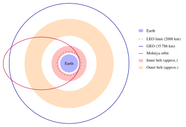
Low Earth orbit (LEO) encompasses altitudes from approximately 200 km—below which atmospheric drag becomes prohibitive for sustained operations—to approximately 2000 km, above which the inner Van Allen radiation belt begins to significantly degrade spacecraft electronics. Key characteristics of LEO include:
-
Orbital period: approximately 88–127 minutes
-
Circular orbital velocity: approximately 7.8–7.1 km/s
-
Free-space path loss: significantly lower than GEO (two-way path: 360 km vs. 72,000 km), enabling smaller ground terminals and lower power consumption
-
Propagation delay: approximately 1–13 ms one-way, compared with 240 ms for GEO
-
Applications: Earth observation, broadband internet constellations (Starlink, OneWeb), ISS, crewed spacecraft, technology demonstration
The primary disadvantages of LEO are: (1) limited contact time per pass from a fixed ground station (typically 5–20 minutes), requiring either onboard data storage or inter-satellite links; (2) the need for large constellations to achieve continuous global coverage; and (3) higher atmospheric drag and debris environment compared with higher orbits.
1.4.2 Medium Earth Orbit (MEO): 2000–35,786 km
Medium Earth orbit lies between the inner and outer Van Allen radiation belts and between LEO and GEO. The most prominent MEO application is navigation:
-
GPS: 20,200 km, 12-hour period, 6 orbital planes, 4 satellites per plane (baseline)
-
GLONASS: 19,100 km, 11.25-hour period
-
Galileo: 23,222 km, 14-hour period
-
BeiDou MEO: 21,528 km, 12.6-hour period
MEO satellites experience the harshest radiation environment of any commonly used orbital regime due to their immersion in the Van Allen radiation belts. Radiation-hardened electronics and heavy shielding are typically required (Stassinopoulos and Raymond 1988).
1.4.3 Geostationary Orbit (GEO): 35,786 km
At an altitude of exactly 35,786 km above the equator (on a circular equatorial orbit), a satellite’s orbital period equals one sidereal day (23 h 56 min 4 s), causing it to appear stationary relative to an observer on Earth’s surface. This remarkable property—first proposed by Clarke—makes GEO ideal for:
-
Broadcasting: A single GEO satellite can continuously illuminate an entire continent; no tracking antenna is required at the receive terminal
-
Meteorological imaging: Continuous hemispheric monitoring with no coverage gaps
-
Point-to-point communications: VSAT networks, maritime and aeronautical satcom
The GEO arc (geostationary ring) is a finite natural resource regulated by the International Telecommunication Union (ITU). With approximately 500 active satellites in GEO as of 2023, slot allocation and interference management are significant engineering and regulatory challenges.
1.4.4 Highly Elliptical Orbits (HEO)
Highly elliptical orbits (HEO), epitomized by the Molniya orbit (period 12 hours, inclination \(63.4^\circ\), apogee \(\approx 40,000\) km, perigee \(\approx 1000\) km), were developed by the Soviet Union in the 1960s to provide communications and broadcasting to high-latitude regions of Russia that are poorly served by GEO satellites. Near apogee, the satellite moves slowly and remains in view of high-latitude ground stations for 8–10 hours per orbit. The Tundra orbit (24-hour period) provides similar high-latitude dwell time with once-per-day ground track repeatability. Chapter 2 provides detailed analysis of these special orbits.
1.5 Classification by Application
1.5.1 Communications Satellites
Communications satellites (comsats) represent the largest revenue-generating segment of the satellite industry. They relay voice, data, video, and internet traffic between ground terminals that may lack line-of-sight connectivity. Modern GEO comsats such as ViaSat-3 offer aggregate throughputs exceeding 1 Tbps using frequency reuse with spot beams, phased-array antennas, and efficient digital processing. The LEO broadband segment (Starlink, OneWeb, Telesat Lightspeed, Amazon Kuiper) promises low-latency, high-throughput internet to underserved and remote populations globally.
1.5.2 Earth Observation Satellites
Earth observation (EO) satellites collect imagery and geophysical data across the electromagnetic spectrum. Commercial EO providers such as Maxar Technologies, Airbus Defence and Space, and Planet Labs operate constellations delivering daily revisit of any point on Earth’s surface. Remote sensing applications include:
-
Agriculture: crop health monitoring (NDVI), yield estimation, irrigation management
-
Forestry: deforestation monitoring, biomass estimation, wildfire mapping
-
Urban planning: building footprint extraction, informal settlement mapping
-
Defense and intelligence: change detection, order of battle assessment
-
Environmental monitoring: sea-surface temperature, ice extent, pollution tracking
-
Disaster response: flood mapping, earthquake damage assessment, tsunami inundation extent
1.5.3 Navigation Satellites
Global Navigation Satellite Systems (GNSS) provide positioning, navigation, and timing (PNT) services to billions of users and trillions of transactions daily. Four complete global systems are operational: GPS (USA), GLONASS (Russia), Galileo (EU), and BeiDou/BDS (China). Regional systems include QZSS (Japan) and NavIC/IRNSS (India). GNSS timing signals underpin financial transaction networks, telecommunications synchronization, power grid management, and the internet.
1.5.4 Scientific and Research Satellites
Scientific satellites serve astronomy, astrophysics, space physics, geodesy, and Earth system science. The Great Observatories program (Hubble, Compton, Chandra, Spitzer) revolutionized astrophysics. The James Webb Space Telescope (JWST), launched December 2021 and operating at the Sun–Earth L\(_2\) Lagrange point, observes in the near- and mid-infrared with unprecedented sensitivity. Geodetic satellites (GRACE, GRACE-FO) measure gravitational anomalies with millimeter precision, enabling measurement of ice sheet mass balance, groundwater depletion, and ocean circulation.
1.5.5 Military and Government Satellites
Military satellites support reconnaissance, early warning, secure communications, environmental monitoring, and treaty verification. The U.S. Space Force operates systems including:
-
SBIRS (Space-Based Infrared System): GEO and HEO infrared sensors for missile warning
-
WGS (Wideband Global SATCOM): X- and Ka-band GEO communications
-
AEHF (Advanced Extremely High Frequency): nuclear-hardened, jam-resistant communications
-
NRO satellites: classified reconnaissance and signals intelligence
1.5.6 Meteorological Satellites
Weather satellites operate in two complementary orbital regimes: GEO for continuous hemispheric monitoring (GOES-East/West, Meteosat, Himawari) and polar LEO for high-resolution global coverage (NOAA/Suomi NPP/JPSS, MetOp, Fengyun). Modern meteorological instruments measure atmospheric temperature profiles, moisture, clouds, winds, sea-surface temperature, ocean color, and land surface characteristics. Numerical weather prediction (NWP) models assimilate satellite data to extend reliable forecast ranges beyond 7 days.
1.6 The Modern Space Economy
1.6.1 Current Market Size and Structure
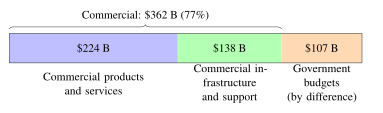
The global space economy reached an estimated $469 billion in 2021, according to the Space Foundation’s Space Report 2022. The commercial space sector accounts for roughly 77% of this total (about $362 billion), dominated by satellite services (broadcasting, broadband, Earth observation, and GNSS value-added services) and the ground infrastructure that supports them. Other industry surveys use different definitions and give different totals, so such figures should be compared only within one source. Figure 1.3 illustrates the split of the 2021 space economy between commercial and government activity.
| Sector | Value (B USD) | Share (%) |
|---|---|---|
| Commercial products and services | 224 | 47.8 |
| Commercial infrastructure and support industries | 138 | 29.4 |
| Government space budgets (civil and military) | 107 | 22.8 |
| Total | 469 | 100.0 |
1.6.2 Growth Projections: The Road to $1 Trillion
Morgan Stanley Research projected in 2020 that the global space economy could exceed $1 trillion by 2040, driven primarily by broadband satellite internet services. Key growth drivers identified include:
-
Broadband LEO constellations: Starlink, OneWeb, Amazon Kuiper, and Telesat Lightspeed collectively could provide global high-speed internet to the billions of people who still lack reliable broadband access, with market forecasts running to hundreds of billions of dollars per year (such forecasts are highly uncertain).
-
In-space services: On-orbit servicing (refueling, life extension, inspection), debris removal, in-space manufacturing, and space tourism represent nascent but rapidly growing markets.
-
Lunar economy: NASA’s Artemis program, commercial lunar lander contracts, and emerging plans for lunar resource extraction and utilization (ISRU) foreshadow a cislunar economic zone.
-
Data-as-a-service: Earth observation analytics, GNSS augmentation services, and space-based IoT connectivity create high-value data products from satellite assets.
1.7 The NewSpace Revolution
1.7.1 Defining NewSpace
The term “NewSpace” (also written as “New Space” or “commercial space”) describes the emergence since approximately 2000 of entrepreneurially funded, commercially operated space ventures that operate with fundamentally different business models, engineering cultures, and cost structures than traditional government primes and their legacy commercial descendants.
Key Characteristics of NewSpace Companies:
-
Rapid iteration: fail fast, learn, and fly again
-
Commercial-off-the-shelf (COTS) electronics and components
-
Software-defined systems and agile development
-
Vertically integrated supply chains
-
Risk tolerance: accepting higher failure probability for lower cost
-
Constellation business models: revenue from services, not satellite sales
1.7.2 SpaceX: The Paradigm Shift
SpaceX (Space Exploration Technologies Corp.), founded by Elon Musk in 2002, has arguably done more to transform the launch services market than any other single entity. Key achievements include:
-
Falcon 9: The world’s first orbital-class booster capable of propulsive landing and reuse. As of early 2024, individual Falcon 9 first-stage boosters had been reflown up to 19 times, reducing amortized launch costs by an estimated factor of 3–5 compared with expendable vehicles.
-
Dragon: The first commercial spacecraft to berth with the ISS (2012) and the first commercial crewed spacecraft (Crew Dragon, Demo-2, May 2020).
-
Starship: The largest and most powerful rocket system ever developed, targeting full and rapid reusability of both stages, with a stated goal of reducing launch costs to below $100/kg to LEO.
-
Starlink: The largest satellite constellation ever deployed, providing global broadband internet service.
The Falcon 9’s price-to-performance ratio forced a global competitive response: legacy providers were compelled to develop new rocket families (Ariane 6, Vulcan Centaur, New Glenn) specifically to compete on cost.
1.7.3 Planet Labs and the Small Satellite Revolution
Planet Labs (now Planet Labs PBC), founded in 2010 by former NASA engineers, pioneered the Dove CubeSat platform: 3U (10\(\times\)10\(\times\)30 cm) satellites with commercial imagers providing approximately 3–5 m resolution. By launching hundreds of Doves into LEO, Planet achieves daily global coverage of Earth’s entire landmass—a cadence previously impossible with large, expensive EO satellites. Planet’s business model of selling data-as-a-service, rather than satellites, exemplifies the NewSpace approach.
1.7.4 Rocket Lab
Rocket Lab’s Electron launch vehicle, operational since 2018, targets the dedicated small satellite launch market. Electron uses an electric-pump-fed engine (Rutherford), 3D-printed in large part from Inconel, and delivers up to 300 kg to LEO. Rocket Lab has pursued reusability through helicopter mid-air recovery of the first stage. Its Photon spacecraft bus provides turnkey satellite services. The company’s Neutron rocket, under development, targets a medium-lift reusable class competitive with Falcon 9.
1.8 Key Enabling Technologies
1.8.1 Reusable Launch Vehicles
The economics of space access are dominated by launch costs, which historically ranged from $10,000 to $50,000 per kilogram to LEO. Reusable launch vehicles (RLVs), pioneered by Space Shuttle (partially reusable; operational 1981–2011) and brought to commercial fruition by Falcon 9, aim to reduce this by one to two orders of magnitude. The technical challenges of RLV development include:
-
Thermal protection: Re-entry heating at 7–8 km/s atmospheric entry velocity
-
Propulsive landing: Precise throttle control and guidance for pinpoint landing
-
Rapid turnaround: Structural refurbishment, propellant loading, inspection, and re-certification in days rather than years
1.8.2 Commercial Off-the-Shelf (COTS) Components
The consumer electronics revolution has produced processors, memory, sensors, and radio components that, while not radiation-hardened to space-grade specifications, offer dramatically superior performance per unit cost compared with traditional space components. Modern small satellite programs routinely use smartphone-grade processors, commercial image sensors, and software-defined radios with appropriate risk mitigation strategies (redundancy, error correction, thermal control) rather than the costly radiation-hardened alternatives mandated by heritage programs.
1.8.3 Additive Manufacturing
3D printing (additive manufacturing) has penetrated satellite manufacturing in propellant tanks (Launcher’s Orbiter), rocket engines (Rocket Lab’s Rutherford, Relativity Space’s Terran 1), and structural components. Additive manufacturing reduces part count, enables complex geometries impossible with subtractive machining, and compresses lead times from months to days.
1.8.4 Artificial Intelligence and Machine Learning
AI and machine learning (ML) are transforming both satellite operations and data exploitation. On the data side, ML algorithms enable automated feature extraction from petabytes of EO imagery—object detection, change detection, land classification—at scales impossible with human analysts. On the operations side, AI enables autonomous anomaly detection, predictive maintenance, and collision avoidance for large constellations. Onboard AI processing (edge computing on satellite) reduces downlink data volume by processing raw sensor data before transmission.
1.9 Regulatory and Spectrum Environment
The radio frequency spectrum used by satellites is an internationally shared natural resource regulated by the International Telecommunication Union (ITU) Radio Regulations. Satellite operators must coordinate frequency assignments and orbital positions to avoid interference. Key frequency bands allocated for satellite services include:
-
L-band (1–2 GHz): Mobile satellite services, GPS
-
S-band (2–4 GHz): Weather satellites, some mobile services
-
C-band (4–8 GHz): Fixed satellite service (FSS), primary GEO comms band
-
X-band (8–12 GHz): Military communications, SAR, meteorology
-
Ku-band (12–18 GHz): Broadcasting, VSAT, FSS
-
Ka-band (26.5–40 GHz): High-throughput satellite (HTS) broadband
-
V-band (40–75 GHz): Emerging ultra-high throughput (under development)
The orbital debris environment is regulated through guidelines from the Inter-Agency Space Debris Coordination Committee (IADC), requiring post-mission disposal of LEO satellites within 25 years and passivation of residual energy sources. The rapid growth of LEO constellations has intensified international debate on debris mitigation, active debris removal, and collision avoidance norms.
1.10 Book Organization and Chapter Overview
This book is organized to take the reader from foundational physics to current engineering practice and future directions in satellite technology. The following provides a brief synopsis of each chapter:
Chapter 2: Orbital Mechanics derives the gravitational two-body problem from first principles, proves Kepler’s three laws, defines the six classical orbital elements, and develops the tools needed to analyze orbital maneuvers, coverage, and perturbations. Special orbits (SSO, Molniya, Lagrange points) are treated in detail. Relative motion and the Clohessy–Wiltshire equations for formation flying are introduced.
Chapter 3: The Space Environment characterizes the radiation, plasma, thermal, debris, and neutral particle environments encountered by spacecraft in various orbital regimes. Radiation effects on electronics—Total Ionizing Dose, Single Event Effects, and Displacement Damage—are quantified, with design implications.
Chapter 4: Launch Systems and Vehicles derives the Tsiolkovsky rocket equation and analyzes multi-stage vehicle performance. Current launch vehicles are surveyed with performance data. Reusable launch technology, payload integration, rideshare, and launch site considerations are covered.
Chapter 5: Spacecraft Systems Engineering introduces the systems engineering process applied to satellite design, covering the V-model, requirements decomposition, budgets (mass, power, link, thermal), interface control, and verification.
Chapter 6: Spacecraft Structures and Mechanisms covers structural design principles, launch load environments, structural analysis methods (finite element), materials selection for space applications, and deployable mechanisms (solar arrays, antennas, booms).
Chapter 7: Attitude Determination and Control derives the equations of spacecraft rotational dynamics, discusses attitude sensors and actuators, and presents control algorithms from simple spin stabilization to three-axis momentum management.
Chapter 8: Propulsion Systems covers chemical, electric, and emerging propulsion technologies, including specific impulse, thruster selection, propellant management, and mission delta-v budgets.
Chapter 9: Power Systems analyzes solar array performance, battery sizing, power distribution, and emerging technologies including nuclear power for deep space.
Chapter 10: Thermal Control treats the thermal environment, passive and active control techniques, and thermal analysis methods.
Chapter 11: Communications Systems develops link budget analysis from first principles, covers modulation, coding, and multiple access schemes, and examines current satellite communication architectures.
Chapter 12: Earth Observation Systems covers imaging system design (resolution, MTF, radiometric sensitivity), sensor types (optical, SAR, radiometer), and data processing chains.
Chapter 13: Future Frontiers examines quantum communications satellites, on-orbit servicing and assembly, lunar and Mars satellite infrastructure, and the long-range vision for a spacefaring civilization.
Key Concepts from Chapter 1:
-
The Space Age began with Sputnik 1 on 4 October 1957; the scientific, commercial, and strategic implications were immediately recognized.
-
Satellites offer unique advantages: global coverage, high vantage point, persistence, and rapid deployment.
-
Orbital regimes (LEO, MEO, GEO, HEO) each have distinct characteristics suited to different applications.
-
The space economy reached $469 billion in 2021 and is projected to reach $1 trillion by 2040.
-
The NewSpace revolution, led by SpaceX, Planet Labs, Rocket Lab, and others, has dramatically reduced launch and satellite costs through commercial practices, COTS components, and reusability.
Problems
-
Calculate the ground track speed of the ISS, which orbits at approximately 408 km altitude with an inclination of \(51.6^\circ\). At what latitude does the ground track reach its maximum? How many orbits per day does the ISS complete?
-
A geostationary satellite at \(0^\circ\) longitude subtends what angle as seen from a ground station at \(45^\circ\)N, \(0^\circ\)E? What is the elevation angle to the satellite?
-
The space economy grew from approximately $325 billion in 2015 to $469 billion in 2021. Calculate the compound annual growth rate (CAGR). If this CAGR continues, in what year does the space economy reach $1 trillion?
-
Compare the one-way signal propagation delays for a LEO satellite at 550 km altitude and a GEO satellite at 35,786 km altitude for a ground station directly beneath each satellite. Discuss the implications for real-time voice communications.
-
Consult publicly available orbital element databases (e.g., CelesTrak). List five active satellites in each of the following orbital regimes: LEO, MEO, GEO. For each, identify the primary mission and operator.
Further Reading
For an introduction to satellite technology and mission design, (Wertz et al. 2011) and (Fortescue et al. 2011) are essential references. The commercial satellite communications industry is surveyed in (Elbert, B.R. 2008) and (Maral et al. 2009). Annual industry statistics are published by the Satellite Industry Association and the Space Foundation (The Space Report); their definitions differ, so totals from different sources should not be mixed.